
The basis for responsible raw material development
Geological prospecting is much more than just the search for usable deposits. It is a scientific process that determines whether a raw materials project can be realised in a sustainable, safe and environmentally friendly manner in the long term. For Ares Maximus, it is the central building block of every project development - and the moment when responsibility begins. Because only those who understand a deposit precisely can minimise interventions, control risks and create a transparent basis for decision-making.
How modern prospection works today
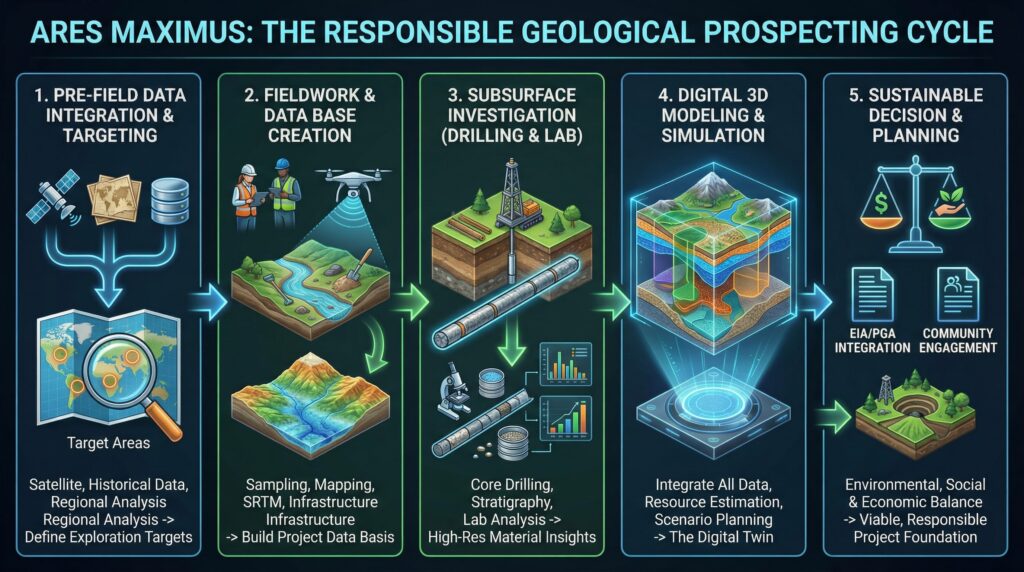
Before a team even begins test drilling, a comprehensive site analysis is carried out. This includes the evaluation of satellite data, existing geological maps, measurement series from previous studies and the investigation of regional characteristics. This preliminary phase helps to assess the natural structures of the area: River courses, depositional zones, slope stability, hydrogeological systems and potential alluvial shifts.
Initial prospecting and exploration targets are defined on the basis of this data. These mark the areas where geological indicators point to diamonds or gold. The quality of this initial assessment determines the efficiency of the entire subsequent investigation.
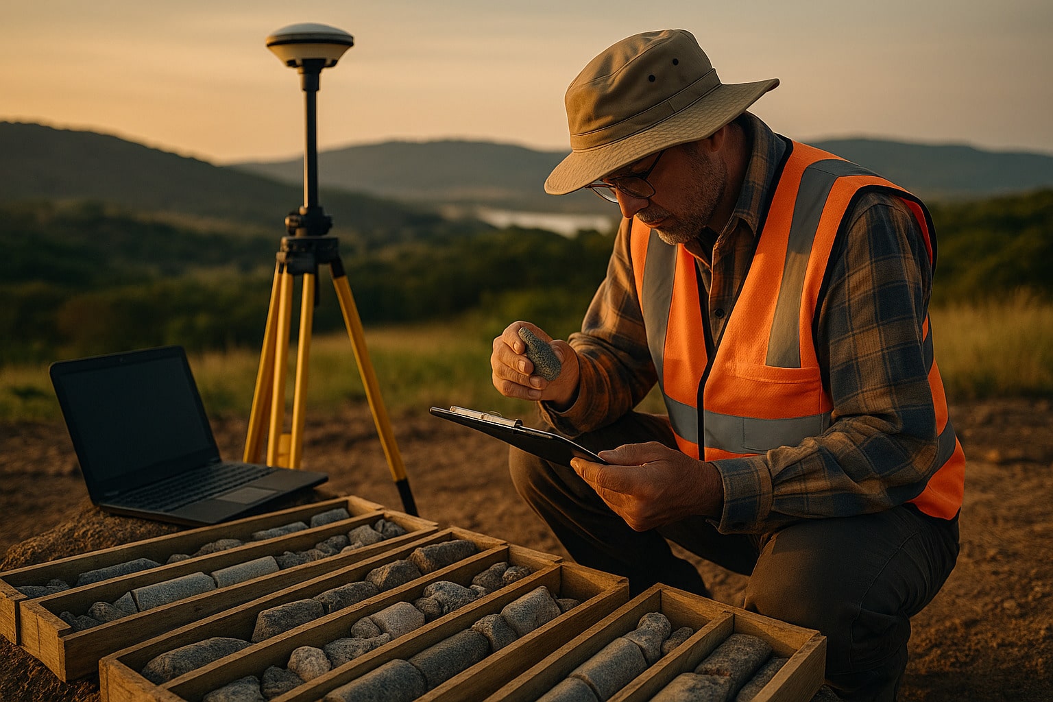
Field work: precision instead of depth of intervention
The actual prospecting begins in the field. Teams of geologists and technicians take samples, measure sediments, map structures and document anomalies. In areas such as Lunda Sul, analysing secondary deposits plays a special role because rivers have shifted material there over many millennia. The systematic extraction of soil, gravel and mineral samples provides information on the distribution of raw materials in the subsurface.
In the first step, the Development of the project-related database. This includes creating an elevation model (SRTM), recording the water network and existing infrastructure and deriving a preliminary geological map based on the aerial image analysis. In addition, all available legacy data is integrated in order to create a consistent, reliable initial data model.
Drill cores - the window into the subsurface
As soon as the field analyses provide a clear picture, targeted core drillings follow. These provide the most important data for the entire investigation. Each drill core shows the stratification, grain sizes, mineral compositions and stability of the rock. Structures relevant to diamonds such as transport zones, conglomerates or alluvial deposits are thus precisely visualised.
The cores are then analysed in the laboratory. Grading curves, density analyses and mineralogical methods are used to create a high-resolution evaluation of the material. This data is combined with the measured values from the surface work - and results in a detailed picture of the deposit.
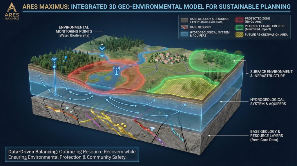
Digital modelling: the step towards a reliable basis for decision-making
Modernity Prospection does not end at the core sample. Digital 3D models summarise all the data and simulate various scenarios: How large is the deposit? Which areas are economic? Where do water-bearing layers run? What stability factors need to be taken into account?
This model is the core of subsequent mining planning. It shows how interventions can be reduced, where protection areas are necessary, which parts of a deposit can possibly be recultivated and which environmental measures need to be taken.
One principle applies to Ares Maximus: Mining only takes place where data is available beyond doubt and environmental compatibility is assured.
Why Prospection & Exploration always means environmental management
An excellent geological model is not enough if it is not embedded in ecological responsibility. That is why Ares Maximus combines the Prospection& Exploration consistently with EIA, PGA, PGR and PRAD programmes.
Water samples, biodiversity measurements, waste management, landscape protection and the protection of sensitive zones are included in the assessment. The aim is to minimise the impact on nature and communities as early as the data collection stage, rather than during extraction.
The teams also work regularly with local authorities and community representatives. This early involvement creates trust and enables clear communication about opportunities, limits and necessary protective measures.
Transparency and diligence as guidelines
Deposit-related investigations are a highly precise procedure - but also a process that requires trust. Ares Maximus ensures that every phase remains documented, traceable and auditable. The combination of technology, environmental responsibility and open communication creates a foundation on which safe and cost-effective projects can be built.
In regions such as Angola, this approach not only contributes to value creation, but also to the stability of local structures and the sustainable development of entire communities.
Conclusion
The raw material-related site analysis determines the character of a project. It shows whether a deposit exists, whether its extraction is responsible and what measures are necessary. Ares Maximus combines scientific precision with clear environmental standards and regional co-operation. The result is a basis that gives projects long-term stability - and protects nature and people.